Amsterdam is a popular tourist destination for North
Americans and Europeans. Even though many of the streets are only for
pedestrians they are still crowded and at times chaotic. One day while walking
on the Kalverstraat my friend showed me a massive door but on that day it was
locked.
Recently we were able to gain entrance and explore the Begijnhof.
Initially the Begijnhof was established in the late 1300’s as a residence for
lay religious women (differing form nuns in that they did not take vows).
Similar Almshouses (Hofjes) were built during the 17th century in
the Jordan district to shelter the widows of sailors.
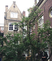
Entering the courtyards of these residences you generally
find a cluster of twelve apartments around a central garden and you forget that
you are in a city. While there are twenty one of these Horfjes still managed by
the local government in the Jordaan district they are private homes so access
to these areas occurs rarely. As a tourist I feel quite fortunate to have seen
three.
We have learned to fear volcanos:
they emit gases, erupt lava and occasionally explode. In many cultures they
have been your “go to” place for human sacrifice. Nicaragua is a country that
straddles two tectonic plates and is part of the Pacific Ring of Fire: you can
literally see the chain of cones. Volcanos in this country preside over the
landscape and offer sanctuaries of biodiversity for plant and animal species,
dormant craters act as reservoirs and porous rock filters water for the farms below.
The Mombacho Volcano features a
cloud rainforest at 1150m with hiking trails that people can enjoy guided or
independently. Downhill from the primary forest you find the coffee growing
area and can either learn about the harvesting process or go zip lining. The Canopy
Zip Line tour is set over seven legs of varying lengths and difficulty. As a
first time zip liner rather than feel intimidated I felt a connection to the
rain forest environment.
Masaya Volcano is much more easily
accessed: it is an active site and the cone has been deforested from an
eruption in the 2013. Drivers can park within twenty feet of the rim to look
into its active caldera. While there are trails around the craters, exploring
the area depends upon wind direction because the gases emitted can make you
sick after a while.
East of Leon, Casa Negro Volcano is
a site for sand boarding (like snow-boarding but on volcanic sand). While
ascending the cone, boarders get to enjoy vistas of the surrounding peaks. It
felt very primal…after reaching the top I got to run the rim trail before
descending on my board. Sand boarding involves wearing coveralls, heavy gloves
and a visor that protect you from the coarse sand. It was much easier than I
expected: the slope looks steep but the sand is deep and offers some resistance
for controlling your speed.
My experience at all three locations felt very “elemental”.
Volcanos are a force of nature but the landscapes they generate are quite
inspiring. Perhaps “experiencing life on the edge” isn’t an entirely bad thing.
I recently had the opportunity to
visit Suchitoto in Northern El Salvador, Puerto Barillas on Jiquilisco Bay and the country’s sun
coast. During my time there I saw nature preserves, heritage architecture and
expansive beaches. In my opinion there are a lot of contrasts and while I felt
intimidated by the razor wire and presence of guns many of the people in the
hospitality industry were genuinely warm. El Salvador has a great potential for
tourism in the next decade.
Suchitoto overlooks a man-made lake
which carries the same name. Traditional Spanish homes mark the cobble stone
streets of this colonial city.During
the civil war of the 1980’s the town sustained heavy bombing and many people
deserted their homes. The government is now working to revive the area as a
tourist destination by restoring and repurposing these abandoned buildings as
hotels and restaurants. While walking the streets we visited the Iglesia Santa
Lucia which is renowned for its interior woodwork and saw a woman selling bread
from a large basket that was perched on her head. The area also hosts avian
tourists: from my terrace at the La Posada de Suchitlán and I saw a variety of
birds and insects then during our afternoon tour of Lake Suchitoto we went to a
massive colony of egrets and cormorants.
In contrast Jiquilisco Bay is a mangrove wetland
which offers protection to a diverse array of species. On my boat trip to the
turtle conservation project I saw a crocodile, spoon bills and a tiger heron. Guests staying at Puerto Barillas have the
opportunity to discover the bay’s wildlife through boat tours, fishing excursions
and kayak rentals. Our group took part in a turtle conservation project that
capture, measures and tags Hawksbill turtles. Part of the Eastern Pacific
Hawksbill Initiative, this project offers visitors the opportunity to
participate in their volunteer program http://www.hawksbill.org/get-involved/volunteer/
.
The Costa del Sol Beach spans a
distance of twelve kilometres and is popular with surfers. The evening I was
there the water was warm and the waves were great for body surfing but also a
little intimidating. This area is located thirty-five kilometres
from San Salvador Airport making it a nice stopover point for passengers
transiting the country.
Currently the destination has some
infrastructure issues: with the exception of the Costa del Sol most tourist
areas have poor road access and English is not well comprehended even within
the hospitality industry. Personal security was always at the back of my mind: even
though a recent customer got a local taxi at the airport I recommend that
visitors pre arrange ground transportation before arrival.
While travel
is about discovering new places and customs it also helps you learn things
about yourself. Food tours provide a great opportunity to try different food
and learn how a city developed in relationship to other cultures. Recently I
enjoyed a food tour of the Jordan area in Amsterdam. Our trip featured some
stereotypical Dutch food but also cuisine inspired by its colonies. Our first
stop was at a traditional “brown café” which is a pub historically decorated in
dark woods.After meeting our group and
enjoying poffertjes with coffee our guide lead us through the area to different
shops and restaurants where we sampled pastries, herring, kibbling, cheeses and
bitterballen. I expected to sampleIndonesian Food however our tour included a Suriname restaurant: this
cuisine had been developed by Indonesians when they immigrated to Suriname. The
fusion of cultures made for a great food experience.
The Neolithic Period commenced about
10000BC and ended between 4500-200BC. As a reference this is the period in
which Jericho was built and Stonehenge erected: it was also the era during
which passage tombs were created beside the Boyne River in Ireland. Today a
world heritage site has been established at Brú na Bóinne which features these
tombs: two of which are accessible to visitors. Knowth and New Grange were both
built about 3200BC and served as ceremonial tombs that incorporated
astronomical clocks into their designs. In the case of New Grange that calendar
function continues today: the passage of that structure is designed so that
light only enters the center of the tomb on the winter solstice. This feature
allowed farmers to determine when spring would occur so that they could
commence planting crops.
Inner Passage at Knowth
The tombs are similar in size but
differ from each other in two ways. Knowth has one passage oriented to the east
with a second to the west and most of the kerbstones around its perimeter have
been decorated with designs. New Grange is slightly smaller with only one
passage (facing to the south) and the front of it was decorated with a design
of black and white stones. The presentation at New Grange includes
a lighting component that mimics the entry of light into the passage which
occurs at the winter equinox. Starting in darkness a flickering beam stretches
across the chamber and you visualize light as a dynamic force and understand
the relevance of the sun in Neolithic culture.
We may marvel at the tombs because of
the methods and labour used to construct them however their carved kerbstones
make them significant. What you see at Brú na Bóinne represents the highest
concentration of megalithic art in Europe. The meanings of the symbols are for
the most part a mystery but one has been interpreted as a calendar and a second as
an astronomical map.
European
cities get crowded during the summer months and Amsterdam is one example:
streets are congested and hotels become expensive. Hoorn, located thirty five
kilometres north of city is a viable alternative for exploring the Netherlands.
Day trips to Amsterdam are feasible but the town itself features historic
buildings, traditional squares and outdoor cafes. Its smaller size makes it
easier to connect with people: on my third day the residents made me feel like
a local. The area is a great location for cycling or walking: cars are
prohibited on several of its streets and the Grote Noord is exclusively a
pedestrian thorough fare. Hoorn became a city in 1357 and its seaport served as
a base for the Dutch East India Trading Company. Touring the area you can see
the old locks to the city’s canals and two towers that served as part of the
original city walls. Many of the buildings built during the Elizabethan Era
still are in use
including the Maria Tower which can be rented as tourist
accommodation. Two dikes now separate Hoorn from the sea and it now functions
as an inland port on the Markermeer. On Saturdays the town hosts a large
Farmer’s market where shoppers can explore a wide variety of food and products.
The Antrim Coast of Northern Ireland extends between
Ballintoy and Portrush. Prior to 1998 political issues discouraged tourism into
this area and it remains relatively rural. On the day I travelled the A2 along
its coastal route the weather was sunny and we had clear views of Rathlin
Island and the Hebrides of Scotland. Many of the scenes from Game of Thrones
are filmed in the area including the sites of Dark Hedges and the
Carrick-A-Rede Rope Bridge. It’s popularity has attracted tourists to the area
and a visit to Dark Hedges, an avenue of mature Beach trees that interconnect
over the road way, should be taken either early morning or late evening, a
second location equally popularized is Carrick-A-Rede Rope Bridge located east
of Ballintoy. The one kilometre path to the bridge is scenic but remember that
you need to buy a ticket at the trailhead before making the hike otherwise you
are not able to cross to the island. Originally fishermen crossed to
Carrick-A-Rede to harvest salmon but now it is managed by the National Trust as
a tourist attraction. The village of Ballintoy is nearby and looks like a great
spot for cyclists or hikers to stay in a bed and breakfast or enjoy a local
pub.
Seven miles away the National Trust
manages a visitor’s center at the Giant’s Causeway. The building itself has won
an architectural award: part of it is set underground so that it is
inconspicuous against the cliffs and its basalt columns echo the geology of the
area. To view the Giant’s Causeway visitors have to walk 800 meters from the
reception down the hill to Port Noffer. Ulsterbus offers service between the
two points during the high season so that tourists may avoid trekking up or
down the hill. I was impressed by the center’s interpretive displays which
traced the theories, fact and fiction of this landform.
Our final callwas a photo stop at Dunluce Castle east of Portrush.This site is also managed by National Trust:
most of the room have fallen in but visitors can view it’s two remaining towers
and walk down to the Mermaids Cave beneath the stronghold (another setting used
in Game of Thrones).